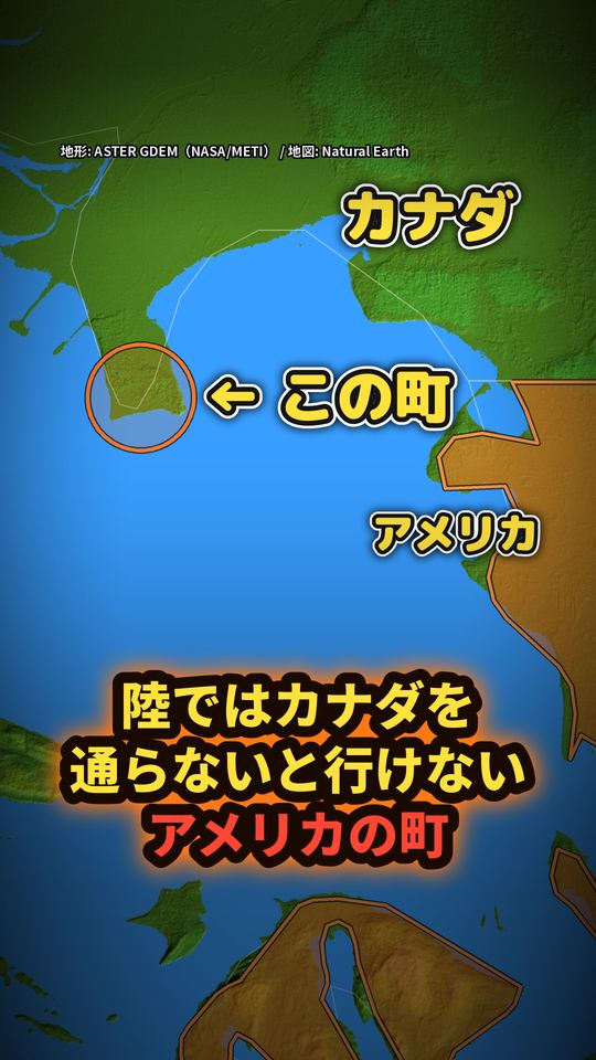
カナダを通らないと陸で行けないアメリカ(ポイント・ロバーツ)
答え
アメリカとカナダの国境の西側は、1846年のオレゴン条約で「北緯49度線に沿って海まで」と決められました。その線がちょうど海に出る所で、カナダから南へ突き出した小さな半島の先だけが49度線の南にはみ出しています。それがアメリカ・ワシントン州のポイント・ロバーツ。半島の付け根はカナダなので、アメリカ本土から陸で行くには、一度カナダに入り、もう一度国境を越える必要があります(船や飛行機でも行けます)。
動画で見る(YouTube・約1分)動画
動画で言ったことと、その根拠
動画の一文ごとに、確かめた資料の原文の該当箇所を引用しています。
1846年の条約で
根拠:「Done at Washington, the fifteenth day of June, in the year of our Lord one thousand eight hundred and forty-six.」(Avalon Project - British-American Diplomcay : Treaty with Great Britain, in Regard to Limits Westward of the Rocky Mountains)
北緯49度の線に沿って、海まで、と決めた
根拠:「continued westward along the said forty-ninth parallel of north latitude to the middle of the channel which separates the continent from Vancouver's Island」(Avalon Project - British-American Diplomcay : Treaty with Great Britain, in Regard to Limits Westward of the Rocky Mountains)
この国境は、全部で8891キロ
根拠:「The Canada–United States border stretches for 8,891 km, or 5,525 miles」(About Us | International Boundary Commission)
隣り合う国の、世界一長い国境よ。
根拠:「This constitutes the world's longest land border between two adjoining countries.」(About Us | International Boundary Commission)
アメリカの町、ポイント・ロバーツ
根拠:「1512573|Point Roberts|Populated Place|Washington|53|Whatcom|073|Point Roberts」(USGS GNIS Washington DomesticNames(Point Roberts・Blaine の行だけを抜き出し。原文そのまま、| 区切り))
はみ出したのは、地図で測って、およそ3キロ。
根拠:「Point Roberts|Populated Place|Washington」(USGS GNIS Washington DomesticNames(Point Roberts・Blaine の行だけを抜き出し。原文そのまま、| 区切り))
となりのブレインから、海の上を、まっすぐなら、約24キロ。
根拠:「1512014|Blaine|Populated Place|Washington|53|Whatcom|073|Blaine…48.9853824|-123.077974」(USGS GNIS Washington DomesticNames(Point Roberts・Blaine の行だけを抜き出し。原文そのまま、| 区切り))
陸の道なら、国境を2回。
根拠:「Point Roberts|Populated Place|Washington」(USGS GNIS Washington DomesticNames(Point Roberts・Blaine の行だけを抜き出し。原文そのまま、| 区切り))
出典
- オレゴン条約(1846年)条文:Avalon Project(Yale Law School)https://avalon.law.yale.edu/19th_century/br-1846.asp
- International Boundary Commission「About」「The Boundary」「Boundary Facts」https://www.internationalboundarycommission.org/
- 地名と座標:USGS Geographic Names Information System(Washington, DomesticNames)
画像・音声の出典
衛星画像:NASA Blue Marble(NASA GIBS)/地形:ASTER GDEM(NASA/METI/AIST/Japan Spacesystems, U.S./Japan ASTER Science Team)/地図データ:Natural Earth
はみ出した長さ(約3km)・ブレインまでの直線(約24km)は地図の形と座標から計算したおおよその値です。陸の道の矢印はおおよその経路です。国境は Natural Earth の表示です。
VOICEVOX:四国めたん
効果音:効果音ラボ