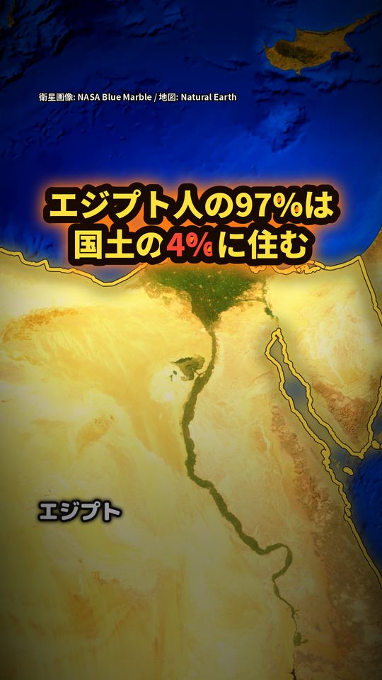
エジプトの人は国のどこに住んでいる?
答え
エジプトの人は、国のどこに住んでいる? FAO(国連食糧農業機関)の AQUASTAT の資料によると、ナイル川の谷と三角州は国土の約4%で、人口の約97%(2004年の推計、人口約7,340万人)がそこに住んでいます。そこでの人口密度は1km²あたり1,165人以上、砂漠では1.2人です。エジプトの面積は約100万km²なので、その4%は約4万km²。日本の国土(377,973.68km²、国土地理院)のおよそ1割の広さです。
動画の中でだいだい色に塗った「帯」は、ナイル川の両側およそ10kmと三角州をおおよそで描いたもので、正確な人口分布の境ではありません。数字は2004年ごろの推計です(新しい公的な数字は見つけられませんでした)。
動画で見る(YouTube・約1分)動画
動画で言ったことと、その根拠
動画の一文ごとに、確かめた資料の原文の該当箇所を引用しています。
国土のたった4パーセント
根拠:「Nile Valley and Delta which occupy about 4 percent of the total」(fao-egypt)
エジプトの人の97パーセント
根拠:「with about 97 percent of all people living in the」(fao-egypt)
その4パーセントが、ここ。ナイル川に沿った
根拠:「interrupted by the Nile Valley and Delta which occupy about 4 percent of the total」(fao-egypt)
川の両側に、人の住む町と畑が集まる
根拠:「Most of the cultivated land is located…close to the banks of the Nile River, its main branches and canals, and in the Nile」(fao-egypt)
南のアスワンから
根拠:「at Aswan」(fao-egypt)
北の首都カイロまで
根拠:「south of Cairo」(fao-egypt)
国の面積の約4パーセント。残りの96パーセントは、ほぼ砂漠
根拠:「Nile Valley and Delta which occupy about 4 percent of the total…The majority of the country area is desert land」(fao-egypt)
わずか1.2人
根拠:「while in the desert it drops to only 1.2 inhabitants/km2」(fao-egypt)
1165人以上。1000倍近い差
根拠:「population density reaches more than 1 165 inhabitants/km2…1.2 inhabitants/km2」(fao-egypt)
人口は2004年の推計で約7340万人。その97パーセント
根拠:「Population is estimated at 73.4 million (2004)…with about 97 percent of all people living in the」(fao-egypt)
エジプトの面積は、約100万平方キロ
根拠:「has a total area of…about 1 million km2」(fao-egypt)
その4パーセントは、約4万平方キロ
根拠:「about 1 million km2…about 4 percent」(fao-egypt)
シナイ半島のカテリーナ山、2629メートル
根拠:「point of the country, at Mount Catherine in Sinai, is 2 629 m above sea level」(fao-egypt)
日本の国土の
根拠:「全 国 377,973.68」(gsi-menseki)
出典
- FAO AQUASTAT「Irrigation in Africa in figures – AQUASTAT Survey 2005」Egypt https://www.fao.org/fileadmin/user_upload/aquastat/pdf_files/EGY_egypt_cp.pdf
- 国土地理院「令和8年全国都道府県市区町村別面積調(7月1日時点)」 https://www.gsi.go.jp/KOKUJYOHO/MENCHO-title.htm (2026年10月24日に確認)
画像・音声の出典
衛星画像:NASA Blue Marble(NASA GIBS)/地図データ:Natural Earth
VOICEVOX:四国めたん
効果音:効果音ラボ